Free Download: Microsoft Pro Photo Tools with Geotag Metadata Support
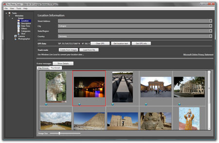
Microsoft Pro Photo Tools provides a set of photography tools for photographers such as to view, add, change, edit and delete common metadata properties for digital photos or pictures, and captures RAW images. It also includes ability to geotag the photos, including latitude, longitude, and other location details. With the help of Microsoft Virtual Earth and Live Search Maps service (previously Windows Live Maps and Windows Live Local), user can place photos on the Live Earth map and then drag them to the right location to automatically tag GPS information into the photos, or load track route files recorded with GPS tracker device in most popular format (NMEA, GPX and KML).
Features of Pro Photo Tools version 1:
Geotagging with flexibility
Determine location name automatically
Determine GPS coordinates from location name
Identify location on a map
View images on a map
Edit image metadata
RAW support
Extensibility
The Pro Photos Tool was subsequently updated to version 2.0, with the following features:
Determine location name automatically
Determine GPS coordinates from location name
Identify location on a map
View images on Windows Live Maps
Use Microsoft Virtual Earth for a 3D view of the image location
Edit image metadata
RAW support
Download setup installer for Pro Photo Tools: ProPhotoTools.msi (no longer available)
Pro Photo Tools works in English locale of Windows Vista and Windows XP (requires .NET Framework 3).
Update: Pro Photo Tools has been discontinued by Microsoft.
LK is a technology writer for Tech Journey with background of system and network administrator. He has be documenting his experiences in digital and technology world for over 15 years.
Connect with LK through Tech Journey on Facebook, Twitter or Google+.

")

 Hotmail")


 Hotmail")